GIS/Geodesign
What is GIS (Geographic information systems)?
Definition: A collection of interacting and interdependent geographic components used to describe the earth. It integrates hardware, software, and data for capturing, managing, analyzing, and displaying all forms of geographically referenced information.
Main purpose:
- Planning and Analysis
- Asset/Data Management
- Operational Awareness
- Field Workforce
Benefits:
- Reveal patterns, trends, and new relationships otherwise not known:
Through spatial analysis, government leaders can take a holistic view of a policy, program, or process to understand how to improve their decisions based on a multitude of factors. To make a proper decision, agencies must look at a variety of regulations, existing programs, and policies. In many cases, this information is difficult to understand in isolation, and the data needs to be looked at through a variety of factors. GIS can simplify complex data, integrate a variety of sources of information, and summarize composite information when viewed spatially. - Improved communications during a crisis:
GIS can help communities plan and respond to a crisis. With GIS, communities can define emergency routes, know location and status of critical buildings, and allocate the proper resources for urgent response. With GIS, organizations can prepare, respond and recover from crisis more efficiently than ever before. - Improved allocation of resources and planning:
By viewing data spatially, government agencies can easily track and view underserved communities and use this information to allocate resources more efficiently; reform policies, or spot distressing trends about communities and offer remediation strategies. - Instantaneous collaboration through the cloud:
Through the cloud, organizations can share maps, data and pertinent information to improve collaboration efforts. In today’s world, collaboration and capitalizing on resources is essential to improving how the public sector delivers services. - Improved transparency for citizen engagement:
GIS provides increased transparency and accountability for citizens. With the combination of the cloud, shared data, maps, and pertinent information, GIS is allowing increased engagement with citizens. GIS shows trends in the community visually and succinctly, which enables a more constructive conversation for government employees.
Why Does GIS Matter?
We humans confine our activities largely to the surface and near surface of the Earth. We travel over it and in the lower levels of the atmosphere, and we go through tunnels dug just below the surface. We dig ditches and bury pipelines and cables, construct mines to acquire mineral deposits, and drill wells to access oil and gas. Keeping track of all this activity is important, and knowing where it occurs can be the most convenient basis for tracking. Knowing where something happens is of critical importance if we want to go there ourselves or send someone there, to find other information about the same place, or to inform people who live nearby. In addition, decisions have geographical consequences. For example, adopting a particular funding formula creates geographical winners and losers, most obviously when the outcome is a “zero-sum game.” Therefore geographic location is an important attribute of activities, policies, strategies, and plans. Geographic information systems (GIS) are a special class of information systems that keep track not only of events, activities, and things, but also where these events, activities, and things happen or exist.
Location is a vital element of many of the problems society must solve. Some of these problems are so routine that we almost fail to notice them (e.g. the daily question of which route to take to and from work). Others are quite extraordinary occurrences and require rapid, concerted, and coordinated responses by a wide range of individuals and organizations; such as the response to natural disasters and emergencies.
Problems that involve an aspect of location, either in the information used to solve them or in the solutions themselves, are termed “geographic problems”. Here are some more examples:
- Health care managers solve geographic problems (and may create others) when they decide where to locate new clinics and hospitals.
- Delivery companies solve geographic problems when they decide the routes and schedules of their vehicles, often on a daily basis.
- Transportation authorities solve geographic problems when they select routes for new highways.
- Forestry companies solve geographic problems when they determine how best to manage forests, where to cut, where to locate roads, and where to plant new trees.
- National park authorities solve geographic problems when they schedule recreational path maintenance and improvement.
- Farmers solve geographic problems when they employ new information technology to make better decisions about the amounts of fertilizer and pesticide to apply to different parts of their fields.
From: Geographic Information Systems & Science (Third Edition)
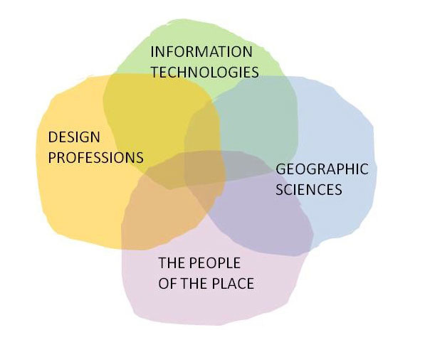
What is Geodesign?
Definition: A method that brings geographic analysis into a collaborative process allowing designers, planners, geographers and civil engineers to find resilient solutions to 21st century urban conditions such as population growth, decreasing resources, disaster mitigation and climate change.
Geodesign is design in a geographic space. The essential aspect of geodesign - the process of designing (creating or modifying) some portion or aspect of the environment, be it natural or man-made - occurs within the context of geographic space.
Main purpose:
As a design and planning method, geodesign tightly couples the creation of design proposals with impact simulations informed by geographic contexts.
The purpose of geodesign is to facilitate life in geographic space.
Benefits:
The referential link between the entity being designed and its geographic context provides the tangible basis for doing both science-based and value-based design. Additionally, it has the ability to provide operational linkages to a wide variety of domain-specific information and, in so doing, provides the multidisciplinary platform for doing integral design (i.e. holistic design).
Visualization tools:
Screen displays, map viewers, video viewers, and tools for displaying reports are one of the most important components of the geodesign system. These tools provide greater depth of understanding and improve communication.
Scenario management tools:
A scenario management tool is beneficial to land-use planning and design projects because you can look at different scenarios and analyze how the plans or designs will influence those projects. E.g., a planner may decide to change the zoning of an area to increase business development; utilizing scenario management tools, he can see how this rezoning might influence traffic in the area.
Improved collaboration:
Geodesign is looking to pick the brain of the individual stakeholders and bring to the surface the less tangible assets they have. This usually involves round table style discussions and brainstorming sessions between the different stakeholders, i.e., practitioners of geographic sciences, IT, design, and citizenry (those that live in and know all the nuances of the space/location). This open discussion allows the team to apply these less tangible assets to assess the current conditions of the space/location, as well as how those conditions affect the creation of something new.